Little Rock Lake-Sartell Pool Drawdown Project Information
A proposal to consider a summer drawdown at Sartell Dam 2018
Recent meetings with Eagle Creek Energy suggested we may need to consider some alternatives to a system-wide longer term drawdown. Maintenance requirements, loss of significant revenue and complexities with FERC licensing made it worthwhile looking at other options. One of which may be operation of the dam at a lower level (IE 2ft below full pool instead of 3ft). Another potential option may be a temporary coffer that would isolate the lake using water inflatable tube dam. Several manufacturers make the products. A potential option may include the use of a temporary dam and pumping after a short (4-5 day) drawdown for a longer term drawdown, within Little Rock Lake and the channel area. In either case, options are available and funding can be acquired to make the project happen. We will be working closely with Little Rock Lake Association and Benton SWCD to put a grant proposal in for the project timeline of Summer 2018.
Common questions about the drawdown
- Why do a drawdown?
The Sartell Dam was built in 1907, which increased the water level over 15 feet in some places, from normal Mississippi River water levels. Little Rock Lake water levels increased over 7 feet. When areas are flooded for that long of a time, plant growth is held back. This lack of root mass and shore stability due to those same roots decaying, allows for increased erosion to take place and less nutrients in the water to be processed. In addition, a significant change took place the way the Little Rock Creek watershed (and the rest of Benton County) was used. Historical records and pre-settlement maps suggest that all of Benton County was shrub and forested prior to land conversion for use by cities, businesses, homesteads and agriculture. This change of a once wetland basin where Little Rock Lake is now), to a larger lake, absorbed significant nutrients over time. A drawdown or lowering of water can help to regain some of that plant material, while allowing some of the nutrients to be processed. The intent is to improve water quality, shoreland stability and increase fish/wildlife habitat. Drawdowns have been done throughout the country and Minnesota with success. - How far would the proposed drawdown bring water levels?
The intent is for a lowering of the level at Sartell Dam for a total of six weeks. Or a short term drawdown to facilitate a temporary coffer installation. There will be some localized differences throughout the Mississippi River, likely near the Rice Bridge, however, the slope of the pool would likely maintain the three foot drop through most of Little Rock Lake and the Sartell Pool. There are maps below that show the potential level at various areas around the lake and river. There may also be a need to drop water levels further down (to seven feet below full pool) to accommodate required maintenance at the Sartell Dam. It is still unknown at this time if that is expected in 2018. - When is the potential drawdown going to happen?
Provided all significant approvals by state, federal and local authorities are met and there was reasonable level of public support; the drawdown would be scheduled for Mid-July 2018 through August 2018. - How fast would it be lowered and raised again?
Federal Energy Regulatory Commission (FERC) license agreements and requirements dictate that the water can not be lowered faster than 0.10 foot per hour (Roughly 30 hours). For refilling, no more than 0.20 foot per hour or 10% of incoming flow, whichever is less (less than 30 hours). - Will the drawdown affect my well?
Extremely unlikely. The vast majority of private wells in the area are greater than 50 ft below the surface. Separate lenses of soil and clay make distinct layers between surface water and ground water. Even with a drawdown, the aquifers that are used for drinking water would not be affected. - Will I still be able to use my boat?
Yes. While the level would be lower than we are used to, there will still be significant water for recreation and angling. A note of caution: Objects that were previously out of reach by most boats may become hazards with a drop in water level. Public access sites will have maintenance performed during this time to allow continued use.
Detailed maps below!
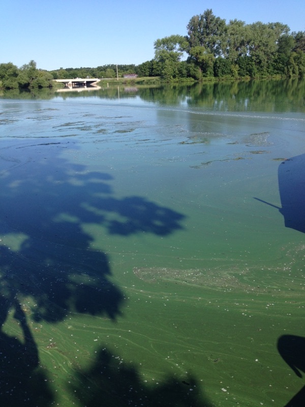
Water quality is an issue on Little Rock Lake. A TMDL was established for the lake in 2011 for excessive nutrients. Water clarity at times is less than a few inches due to pervasive algal blooms.

Many efforts have been made in the watershed to try and address the source of excess nutrients including: alternative farming, irrigation, manure management and septic system upgrades. Despite these improvements there are still water quality issues on the lake. Something more large-scale needs to be done to address the problem.
The 2012 TMDL report suggests a large portion of the higher phosphorous loading has come in during spring runoff events and then remains resident in the lake basin (Internal Loading). None of the suggested alternatives have attempted to address internal phosphorous loading.
Benton County Little Rock Lake TMDL Page
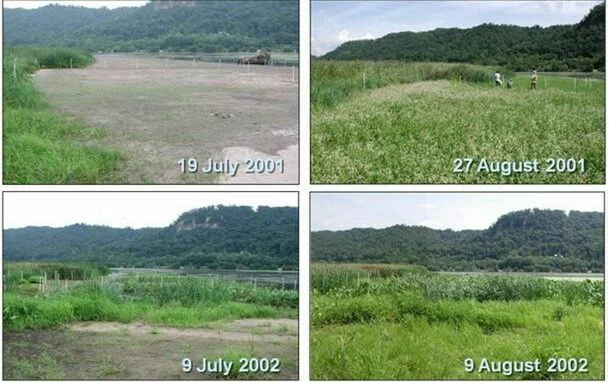
Drawdowns have been shown as effective methods to process nutrients in the soils, stabilize shorelines, increase water clarity/quality and provide valuable fish/wildlife habitat. The proposal would be for six weeks, likely starting around the second week of July through the end of August 2018. It will affect recreation to some extent in both the Mississippi River up to the Rice Bridge (Couty Road 2), Little Rock Lake itself and will likely make navigation through the Harris Channel extremely limited.Pictures from the Mississippi River Pool 8 Drawdown, 2001 and 2002.
Drawdowns have been used throughout the country and in Minnesota as a management tool to improve fish/wildlife habitat, improve water quality and manage nuisance vegetation or fish. Typically, a frequency of summer drawdowns every 7-10 years has been proven effective at maintaining water quality and habitat standards. However, each reservoir complex is different.
The Sartell pool and Little Rock Lake have an artificially maintained stable water level that has not changed since 1908, when the dam at Sartell was installed. Natural systems have a natural rise and fall which builds stability in the sediments and plant growth. Little Rock Lake and the Sartell Pool are still adjusting to this day.
Some potential submerged vegetation growth may occur in areas that may not have been visible in the past. There are provisions within the DNR Aquatic Plant Management Program (APM) to control certain areas and types of plants without a permit. Please see APM Permit Information
Little Rock Channel and 15 miles of the Mississippi River (Two Rivers Campground- Sartell Dam) were mapped late April-early May 2016 and maps were created with the help of Biobase. Little Rock Lake was also mapped in May. The information was used to calculate more accurately how much area will be exposed if or when a drawdown does occur. The information is available on the Insight Genesis website in a downloadable format for Lowrance units. it is available as a “Social Map” on the Insight Genesis website.
River and Lake Contour Maps in PDF format from Two Rivers Campground to Sartell Dam in order from upstream to downstream 1:5000 view. Each map shows the areas that would be exposed if there was a three foot drawdown. Also shown are single foot contours of the river and Little Rock Lake.
River Map 1 | River Map 2 | River Map 3 | River Map 4 | River Map 5 | River Map 6 | River Map 7 | River Map 8 | River Map 9 |
River Map 10 | River Map 11 | River Map 12 | River Map 13 | River Map 14 | River Map 15 | River Map 16 | River Map 17 | River Map 18 |
River Map 19 | River Map 20 | River Map 21 | River Map 22 | River Map 23 | River Map 24 | River Map 25 | River Map 26
Lake Map – Upper | Lake Map – Middle | Lake Map – Lower | Lower Basin – North | Lower Basin – South | Harris Channel
Where is the process now – March 2017?
- Presentations have been given to Little Rock Lake Association, Rice Sportsmen’s Club, River Property owners, City of St. Cloud, Mississippi Partners, Stearns County, Benton County, Anoka Sandplain Partnership and City of Sartell.
- Development of a management plan is under way for agency review.
- Lake association and involved stakeholders are developing a funding plan to work with Eagle Creek Energy to accomplish the drawdow in the summer of 2018. All options are being researched.